Python: Result discrepancy between cv.MinAreaRect2 and ArcGIS (GIS software) . Possible bug? [closed]
I have a set of points derived from a polygon. I am testing several solution in order to obtain the minimum area or the rectangle in Python. As benchmark I am using ArcGIS (10.1).
this post is also in StackOverflaw
points = [(560036.4495758876, 6362071.890493258),
          (560036.4495758876, 6362070.890493258),
          (560036.9495758876, 6362070.890493258),
          (560036.9495758876, 6362070.390493258),
          (560037.4495758876, 6362070.390493258),
          (560037.4495758876, 6362064.890493258),
          (560036.4495758876, 6362064.890493258),
          (560036.4495758876, 6362063.390493258),
          (560035.4495758876, 6362063.390493258),
          (560035.4495758876, 6362062.390493258),
          (560034.9495758876, 6362062.390493258),
          (560034.9495758876, 6362061.390493258),
          (560032.9495758876, 6362061.390493258),
          (560032.9495758876, 6362061.890493258),
          (560030.4495758876, 6362061.890493258),
          (560030.4495758876, 6362061.390493258),
          (560029.9495758876, 6362061.390493258),
          (560029.9495758876, 6362060.390493258),
          (560029.4495758876, 6362060.390493258),
          (560029.4495758876, 6362059.890493258),
          (560028.9495758876, 6362059.890493258),
          (560028.9495758876, 6362059.390493258),
          (560028.4495758876, 6362059.390493258),
          (560028.4495758876, 6362058.890493258),
          (560027.4495758876, 6362058.890493258),
          (560027.4495758876, 6362058.390493258),
          (560026.9495758876, 6362058.390493258),
          (560026.9495758876, 6362057.890493258),
          (560025.4495758876, 6362057.890493258),
          (560025.4495758876, 6362057.390493258),
          (560023.4495758876, 6362057.390493258),
          (560023.4495758876, 6362060.390493258),
          (560023.9495758876, 6362060.390493258),
          (560023.9495758876, 6362061.890493258),
          (560024.4495758876, 6362061.890493258),
          (560024.4495758876, 6362063.390493258),
          (560024.9495758876, 6362063.390493258),
          (560024.9495758876, 6362064.390493258),
          (560025.4495758876, 6362064.390493258),
          (560025.4495758876, 6362065.390493258),
          (560025.9495758876, 6362065.390493258),
          (560025.9495758876, 6362065.890493258),
          (560026.4495758876, 6362065.890493258),
          (560026.4495758876, 6362066.890493258),
          (560026.9495758876, 6362066.890493258),
          (560026.9495758876, 6362068.390493258),
          (560027.4495758876, 6362068.390493258),
          (560027.4495758876, 6362068.890493258),
          (560027.9495758876, 6362068.890493258),
          (560027.9495758876, 6362069.390493258),
          (560028.4495758876, 6362069.390493258),
          (560028.4495758876, 6362069.890493258),
          (560033.4495758876, 6362069.890493258),
          (560033.4495758876, 6362070.390493258),
          (560033.9495758876, 6362070.390493258),
          (560033.9495758876, 6362070.890493258),
          (560034.4495758876, 6362070.890493258),
          (560034.4495758876, 6362071.390493258),
          (560034.9495758876, 6362071.390493258),
          (560034.9495758876, 6362071.890493258),
          (560036.4495758876, 6362071.890493258)]
One solution is use cv.MinAreaRect2() of OpenCV.
The function cv.MinAreaRect2 finds a circumscribed rectangle of the minimal area for 2D point set by building convex hull for the set and applying rotating calipers technique to the hull.
   import cv
# (x,y) - center point of the box
# (w,h) - width and height of the box
# theta - angle of rotation
((x,y),(w,h),th) = cv.MinAreaRect2(points)
print ((x,y),(w,h),th)
((560029.3125, 6362065.5), (10.28591251373291, 18.335756301879883), -63.43495178222656)
# get vertex
box_vtx = cv.BoxPoints(((x,y),(w,h),th))
print box_vtx
((560035.1875, 6362074.0), (560018.8125, 6362066.0), (560023.4375, 6362057.0), (560039.8125, 6362065.0)
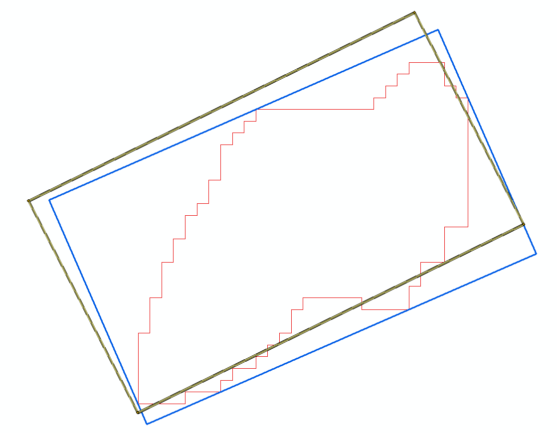
when I convert box_vtx in a shapefile in order to view in ArcGIS and compare with Minimum Bounding Geometry (Data Management) I can see this difference as shown in the following picture, where:
- red = border of polygon
- blue = rectangle with minimum area from ArGIS (10.1)
- yellow and black = rectangle with minimum area from OpenCV
Closed for the following reason
question is not relevant or outdated by
sturkmen
close date 2020-10-08 16:09:42.299770
add a comment